CHAPTER
ONE : INTRODUCTION
GENERAL INFORMATION
The Town of Branford encompasses about 28.0 square miles, 22.0 of
which is land, and is located in New Haven County. Much of the Town
is located in the South Central Eastern Regional Complex of the
South Central Connecticut Coastal Basin situated at an elevation
between 360 ft and sea level. The landscape has been shaped by a
variety of processes, most notably glaciers and tectonic activities
of the past and, more recently, anthropogenic modifications.
The Town of Branford was home to Amerinds (native Americans) before
being settled by European colonists during the early 1600's. Within
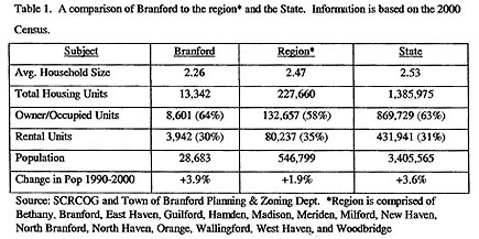
the last 350 years the Town has grown to a population of 28,683
(Source: 2000 Census) living in 13,342 housing units. Owner-occupied
housing units account for 8,601 units and rentals account for 3,942
units. The remainder of units are split between "other families"
(non-traditional families) and unoccupied space. The median household
income is over $50,000/year with an average of 2.26 persons/household
at an average age of 41.4 years old. There are over 1050 business
establishments in Town with combined retail sales of over 620 million
dollars. The Town offers a variety of municipal services including
libraries, education, recreation, waste removal and recycling, sewerage
treatment, and police and fire services among others.
Due to its position on the coast between New York and Boston, a
number of major transportation routes service the area including
Interstate 95, Route 1 and the Northeast Corridor railroad line
(Amtrak) with a Shoreliner station in Branford. Although not as
important as in the past, its coastline is well suited for marine
transport services (Branford and Stony Creek Harbors).
The climate is typical of this area of Connecticut. The average
yearly temperature is 53 oF being slightly moderated from its proximity
to the Long Island Sound (NOAA 1981). Snowfall typically occurs
between December and March with annual accumulations of about 25
inches, although this has dropped slightly in recent years.
The Town of Branford is somewhat representative of both the region
and the State. Table 1 shows some of these comparisons based on
the 2000 census. For example, Branford has fewer individuals per
household than any other town within the region. Age wise, the Town
is slightly older than the average for the region. Median age is
41 and Branford has the 4th highest percentage of people 65 and
older (16.9%) while being 2nd lowest in 18 years and younger (20.7%).
Within the Town, 94% are Caucasian, 1.3% are African Americans,
2.6% are Hispanic and 2.7% are Asian. Within the region and the
State, 77.6% and 81.6% are Caucasian, 12.9% and 9.1% are African
Americans, 9.8% and 9.4% are Hispanic and 2.8% and 2.4% are Asian,
respectively.
NATURAL RESOURCES INVENTORY
In response to the Town of Branford's need to compile a central
database for its natural resources, a Natural Resource Inventory
(NRI) was commissioned by the Town's Conservation Commission. Natural
resource inventories are important documents that can be utilized
in a number of ways, including formulating conservation plans, providing
information on open space acquisitions, and identifying problem
areas in the environment that may require additional action.
The information in this NRI was obtained from a number of sources
including the CTDEP, the Town Planner's Office, the Inland Wetland
& Watercourse Agency, the Fire Dept., the East Shore Health District,
the Town Engineer's Office and the Parks & Recreation Dept among
others. Included in this report are the holdings of the Branford
Land Trust, Inc., a private non-profit organization important in
maintaining open space in Town. Although the information in this
report could never be considered complete (resources are constantly
changing), it does provide a snapshot into the Town's resources
that should be useful to Town managers for years to come. By providing
the information in a single source, it becomes easier to update
the inventory every ten years or so and keep the information relevant
into the future.
The NRI has been divided into a number of chapters based on the
available information. General landscape characteristics and mineral
resources are noted in the Physical Features and Water Resources
chapters. Plants and animals are listed in the Biologic Communities
chapter with some additional information in the Land-Use chapter.
A separate Problems chapter has been included and lists both natural
(i.e., flooding) and anthropogenic (i.e., landfills) sources. In
order to facilitate assessment of the information, much of the data
is presented on maps located throughout the report. The narrative
does not attempt to repeat the information contained on the maps,
but rather is used to single out important concepts and examples
for discussion purposes only. The information contained in this
report is meant to identify general trends and should not be used
for site-specific data (e.g., flood hazard information for home
insurance purposes). For detailed information on any one site or
problem in Town, it is suggested that the Town offices be contacted
directly (e.g.., Town Engineer for flood hazard maps and current
regulations).
|